


HAUTE VALLEE DU DADOU

CASSISFRAMBOISE
User
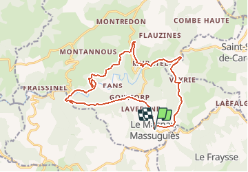

Length
17.7 km

Max alt
819 m

Uphill gradient
514 m
Km-Effort
25 km

Min alt
525 m

Downhill gradient
516 m
Boucle
Yes
Creation date :
2020-02-12 15:01:58.195
Updated on :
2020-02-12 15:02:26.203
--
Difficulty : Medium

FREE GPS app for hiking
 SityTrail
IGN / Geographical institutes
SityTrail Plus
The world is yours!
About
Trail On foot of 17.7 km to be discovered at Occitania, Tarn, Le Masnau-Massuguiès. This trail is proposed by CASSISFRAMBOISE.
Positioning
Country:
France
Region :
Occitania
Department/Province :
Tarn
Municipality :
Le Masnau-Massuguiès
Location:
Unknown
Start:(Dec)
Start:(UTM)
463957 ; 4847287 (31T) N.
Comments